

Indoor positioning is rarely a project of its own. It has to fit into an app that already exists, a building that is already full of infrastructure, and the systems that run the business. That is why indoor positioning integration matters as much as accuracy. IndoorAtlas is built to be the location layer in the middle: it works on its own, makes the systems you already have more useful, and passes positions, maps and events to whatever needs them.
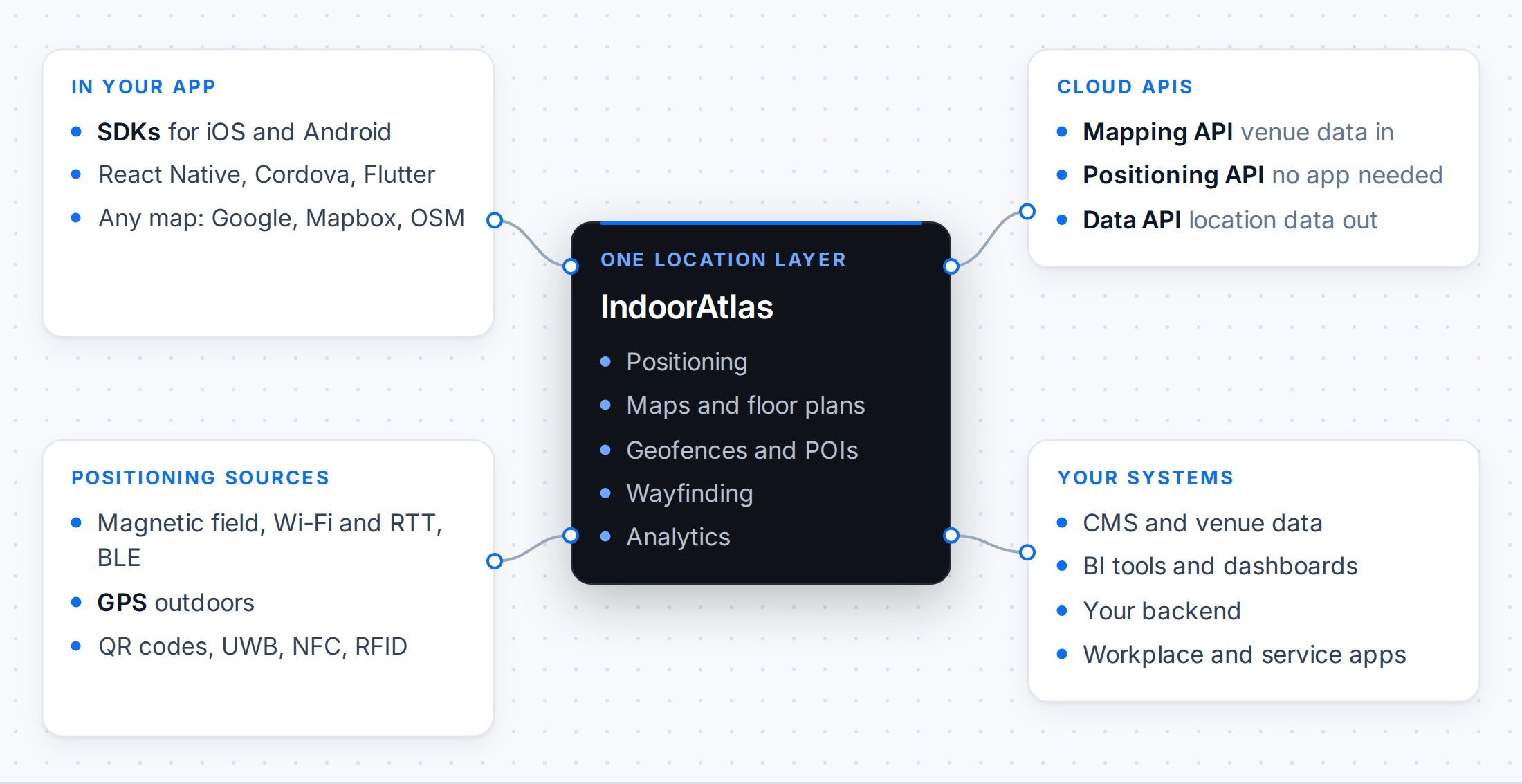
Start from what the building already has
Every building has a magnetic field, and IndoorAtlas uses it as the base of its positioning. That is why a deployment does not have to start with new hardware:
- Wi-Fi and beacons as they are. Existing access points and BLE beacons become extra inputs to the positioning, not something to replace.
- The devices your staff already carry. IndoorAtlas runs on phones and on Zebra mobile computers, so the location comes with the device.
- Your Wi-Fi network for equipment. On HPE Aruba Networking networks, the same access points can also locate tagged equipment: see IndoorAtlas Assets and existing Wi-Fi networks.
- Apple indoor positioning. In venues that have it, IndoorAtlas adds accuracy to Apple’s location on iPhones.
In your app: one SDK
The IndoorAtlas SDK is available for iOS and Android, with plugins for React Native, Cordova and Flutter. It gives your app positions, floor changes, geofence events, points of interest and wayfinding. Positions are standard latitude and longitude with a floor number, so you can draw them on Google Maps, Mapbox, OpenStreetMap or your own map view.
IndoorAtlas positioning works on its own, without any other positioning system, and the same positioning runs on Android and iOS, so one app and one deployment serve both platforms:
- Indoors, IndoorAtlas sensor fusion combines the magnetic field, Wi-Fi (including Wi-Fi RTT), BLE beacons, the motion sensors and the barometer.
- Outdoors, the SDK passes the phone’s GPS location through and notices when the user walks into or out of a building.
IndoorAtlas can also use other location sources where they exist, such as QR codes, UWB, NFC or RFID. A QR code on a kiosk or a sign, for example, gives the starting point for the visitor’s route.
Whatever the source, the app gets one stream of locations through the same API.
In the cloud: three REST APIs
| API | What it does |
|---|---|
| Mapping API | Sets up and updates venues from your own data: floor plans, geofences, points of interest, wayfinding graphs, beacons and access points, as GeoJSON. |
| Positioning API | Locates devices that cannot run the SDK, such as laptops, wearables and IoT devices, from a Wi-Fi or iBeacon scan. |
| Data API | Delivers positioning sessions, with their positions and geofence events, to dashboards, BI tools and your own backend. |
See REST APIs for an overview, or the API reference for the details.
In your business systems
These building blocks are how indoor location ends up inside the products people already use. A hospital app can guide patients to the right clinic, an event app can show visitors the way to a stand, and a shopping centre app can lead shoppers to a store, while their content systems keep the venue data up to date through the Mapping API and the location data flows back to their own dashboards. IndoorAtlas positioning is also built into other companies’ products, for example for indoor wayfinding in ServiceNow’s Now Mobile app (see Get directions to a workplace).
Getting started
Most integrations start small: the SDK in an existing app, one venue, and one system connected through an API. Start a free 30-day trial, or talk to us about your setup.