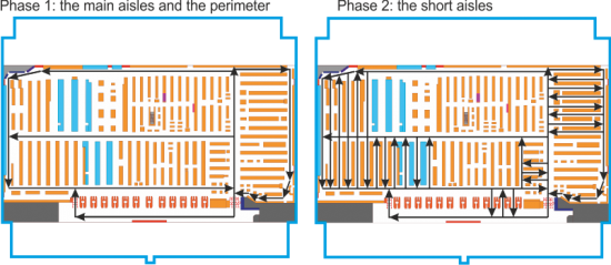
Stores are an interesting application environment for IndoorAtlas’ technology. However, choosing the right mapping approach for a retail store can be challenging. Here are a few tips & tricks you may find useful! A good way to start is to map first the main aisles and the perimeter of the store. It’s then easier to connect the short aisle segments one-by-one to these main segments. This is illustrated in the two figures below. You may also want to do the mapping during the quiet hours. Also ensure that you connect the map segments (aisles) if they connect in real life – this makes the positioning work better. Hopefully your mapping session will be a bit more easier next time!
Read more
-
Blog Code Chronicles – Beacon Management Update
Beacon Management Update We’re excited to announce the latest IndoorAtlas Beacon Management Update, which brings new features to the IndoorAtlas Web Tool. Managing BLE beacons is now…
-
Blog Code Chronicles – October 2024
We’re excited to roll out some key improvements and fixes to the IndoorAtlas Web App that will enhance your wayfinding projects and make working with floor plans smoother.…
-
Blog SDK 3.6.9 Released
IndoorAtlas SDK 3.6.9 has been released. Please find the changelog below: iOS Changelog: Implemented workaround for non-working barometer sensor due to iOS 17.4 bug. For more details, refer…
-
Newsletter IndoorAtlas Newsletter – February 2024
Newsletter February 2024 Welcome to the IndoorAtlas Newsletter. Our newsletter is dedicated to providing you with timely updates on the latest developments within IndoorAtlas. We aim to…
-
Newsletter IndoorAtlas Newsletter October 2023
The IndoorAtlas Newsletter aims to keep you updated on the latest happenings within IndoorAtlas. We strive to provide you with information on the most recent technology and…
-
Blog Re-introducing IndoorAtlas Heatmap
Explore your data with the Heatmap tool The heatmap tool for exploring IndoorAtlas positioning data started as a hackathon project, and later proved itself an invaluable tool in…